SECTION I-- SANDIA LAB'S MIXED WASTE LANDFILL IDENTIFICATION OF PROBLEMS AND UNRESOLVED ISSUES
The Mixed Waste Landfill (MWL) is located in a growing, urban area approximately 460 ft above the aquifer that supplies Albuquerque, New Mexico's public drinking water. The MWL wastes were dumped in unlined pits and trenches, with no engineered system in place for detection and collection of toxic liquids moving beneath the dump. The MWL covers 2.6 acres of technical area 3 at Sandia National Laboratories (SNL). (See Figure 3).
The MWL dump has an estimated 1,500,000 cu ft of radioactive and mixed hazardous wastes from making nuclear weapons. Sandia officials cannot fully say what is really in the MWL dump. The wastes lie above Albuquerque's drinking water aquifer in plastic bags, cardboard boxes and steel drums (See figures 4 and figure 5).
Contamination from cadmium, nickel, chromium, nitrates and possibly PCE has reached the groundwater below the MWL dump. Tritium is entering air and soil. Over 100 drums containing Plutonium-239 and Americium-241 mixed waste will be a threat for tens of thousands of years.
The landfill was operational from March 1959 to December 1988, accepting radioactive and hazardous wastes from both SNL and other sites. The inventory of wastes deposited in the landfill from 1959 to 1964 is still classified by the Department of Energy and is unavailable.
The MWL dump lies approximately one mile near the Mesa del Sol residential development for 80,000 to 100,000 people and a planned children's park. The MWL is north of the Pueblo of Isleta lands and east of communities in the South Valley. The MWL dump is approximately 5 miles southeast of Albuquerque International Sunport.
By today's health and safety standards mixed radioactive and hazardous wastes should never be disposed of near residential neighborhoods. Yet, that is what Sandia and the New Mexico Environment Department (NMED) decided to allow without having reliable information from a groundwater monitoring network about the movement of the wastes beneath the dump.
No reliable groundwater monitoring network has ever been in place to monitor the groundwater beneath the dump.
- The New Mexico Environment Department, the Environmental Protection Agency and DOE/Sandia knew in the early 1990s that the groundwater monitoring wells were put in the wrong locations at the MWL dump.
- Shortly after four monitoring wells were installed to the north and west based on an assumed flow of groundwater to the northwest, it was learned groundwater flow was to the southwest.
- The monitoring wells were improperly positioned, providing data that could not possibly be accurate.
- The regulatory agencies also knew that the wells had corroded well screens and were contaminated with Bentonite clay that hides evidence of contamination
Nevertheless, the NMED accepted the erroneous data to make the decision in 2005 to leave the MWL dump wastes in place under a dirt cover.
The 1998 NMED Notice of Disapproval (NOD) Report required DOE/Sandia to install two new monitoring wells west of the MWL dump with the well screens installed across the water table in the fine-grained alluvial fan sediments. Accordingly, wells MWL-MW5 and - MW6 were installed west of the MWL dump in 2000. However, the geologic cross-section in Figure 6 shows that the screens in the two monitoring wells were installed too deep for the intended purpose to monitor at the water table in the fine-grained alluvial fan sediments.
A congressionally appointed commission called WERC investigated the MWL but was not provided information regarding the out of place, defective groundwater monitoring network. The data from the flawed groundwater monitoring wells was accepted by WERC as correct and as being from a reliable monitoring network.
Witnesses for Sandia and the Environment Department incorrectly testified at the December 2004 public hearing for the dirt cover remedy that there were reliable monitoring wells and "no evidence of contamination to the groundwater." The administrative record shows that:
- knew that the monitoring network was in the wrong location,
- incapable of detecting contamination and that
- the data from the wells was not reliable to make the remedy decision to leave the wastes in place.
Sandia Labs saved hundreds of millions of dollars by not treating or excavating the wastes while putting public health and the environment at risk.
In 2007,Citizen Action and Registered Hydrogeologist Robert Gilkeson filed a complaint with EPA Region 6 that the monitoring well network was defective.
A $275,000 investigation (April 2010) by the Environmental Protection Agency Office of Inspector General found that:
- EPA Region 6 staffers had concerns similar to Citizen Action's about the landfill's affect on groundwater and the lack of effective groundwater monitoring at the MWL dump.
- the Oversight Report of the EPA staff's MWL dump concerns are still being kept secret from Citizen Action and the public.
EPA Region 6 and the EPA Office of Inspector General are both withholding secret documents that show the groundwater monitoring at the MWL dump did not support the decision to leave the wastes in place under a dirt cover.
New Mexico Environment Department uses flawed data and disregards public concerns. The New Mexico Environment Department sued Citizen Action to keep a 2006 TechLaw, Inc. taxpayer paid report secret until late 2009. The TechLaw report:
- reveals flaws in the dirt cover construction for long term protection,
- rejects Sandia's computer modeling for movement of the dump's wastes as a "black box" that should not be used.
NMED withheld the TechLaw report during public meetings about wastes reaching groundwater. NMED withheld the TechLaw report from the EPA Inspector General. NMED used the flawed Sandia computer model in responses to the public to wave aside their concerns.
New wells installed in 2008 are too deep to monitor at the water table level for detection of contamination.
- The drilling operations were incorrect and the well screens are too long at 30 feet.
- The sampling is done improperly.
- Sandia, EPA and the NMED know that data from the current well monitoring network is highly flawed.
- Nevertheless, Sandia continues to submit the useless data, NMED continues to accept the false data for decisions and EPA continues to withhold its reports from the public.
Sandia incorrectly states that no liquids were in the MWL dump. However, for five decades:
- Storm water run-on pooled in the MWL unlined pits and trenches;
- 271,500 gallons of reactor coolant wastewater containing hexavalent chromium was deposited in Trench D at the MWL (See Figure 5);
- 5,000 gallons of water were pumped into Trench B to extinguish a depleted uranium fire in 1974.
- From June 2006 through July 2007, heavy rainfall breached berms that were supposed to prevent storm water from flowing across the site. Storm water run-off entered the MWL for decades.
The MWL dump wastes have already begun to enter the groundwater.
- Nickel, chromium, cadmium and nitrate appeared in older defective monitoring wells that were installed in 1988 and 1989.
- Soil vapor studies conducted in 2007 show that cancer causing volatile organic solvents are moving deeper beneath the MWL dump but were not investigated below the 50 ft depth.
- Tritium concentrations are ten times higher and found at deeper levels than a decade ago.
- Sandia computer models predicted groundwater contamination from the solvent PCE by 2010.
- The presence of the dirt cover will actually accelerate the movement of solvents to the groundwater.
The DOE uses the MWL dump as a success model for how DOE should dispose of radioactive wastes under dirt covers at Sandia, Los Alamos National Laboratory and other sites in the nuclear weapons complex.
The dirt cover installed over the Sandia MWL dump will not prevent releases of waste from nuclear weapons production to future generations. Radioactive wastes such as Plutonium and Americium placed in the MWL dump will remain dangerous to air and water for tens of thousands of years.
REFERENCES
Figure 1. Location of the Sandia "Mixed Waste Landfill" (the Sandia MWL Dump) at Sandia National Laboratories Albuquerque Facility inside the Kirtland Air Force Base (KAFB). The map shows locations of drinking water supply wells and nearby Mesa Del Sol Subdivision and Pueblo of Isleta
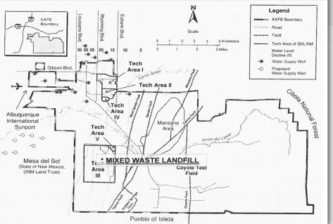
Figure 2. Map of the 2.6 acre Sandia Mixed Waste Landfill (Sandia MWL dump) showing the locations of the unlined disposal pits in the 0.6-acre Classified Area and the unlined disposal trenches in the 2-acre Unclassified Area.
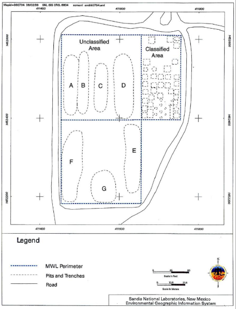
Source: Figure 1-3 in Sandia Report SAND 2002-4098 (Goering et al., 2002).
Figure 3. Aerial view of Sandia MWL dump looking to southwest in 1987. Trench F in the southwestern part of the Unclassified Area is open.
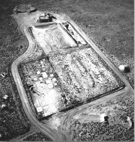
Source: Figure 3 in Final Report - Independent Peer Review of the U.S. Department of Energy Sandia National Laboratories' Mixed Waste Landfill August 31, 2001 Performed by WERC: A Consortium for Environmental Education and Technology Development
Figure 4. View of wastes dumped into unlined Trench F in the Unclassified Area of the Sandia MWL dump. Picture in 1987 with view looking south.
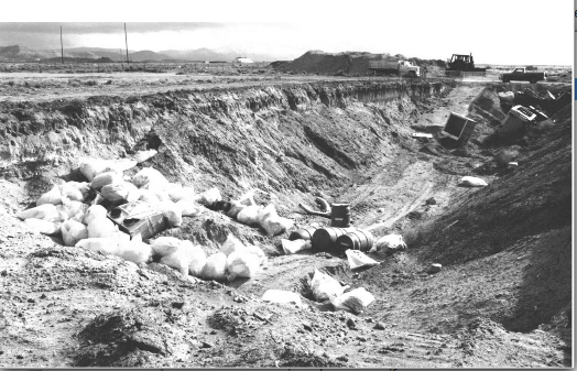
Source: Figure 7 in Final Report - Independent Peer Review of the U.S. Department of Energy Sandia National Laboratories' Mixed Waste Landfill August 31, 2001 Performed by WERC: A Consortium for Environmental Education and Technology Development
Figure 5. View of wastes dumped into unlined Trench D in the Unclassified Area of the Sandia MWL dump. Picture in 1966 with view looking south.
NOTE: In 1967 270,000 gallons of reactor coolant waste water was disposed of into the wastes dumped into Trench D as of 1966.
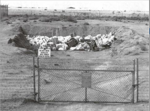
Source: Figure 8 in Final Report - Independent Peer Review of the U.S. Department of Energy Sandia National Laboratories' Mixed Waste Landfill August 31, 2001 Performed by WERC: A Consortium for Environmental Education and Technology Development
Figure 6. Schematic of the Monitoring Wells and the Hydrogeologic Setting at the Sandia MWL dump. The permeable sands and gravels in the Ancestral Rio Grande "A Deposits (ARG deposits) are the valuable groundwater resource for Albuquerque and the surrounding region.
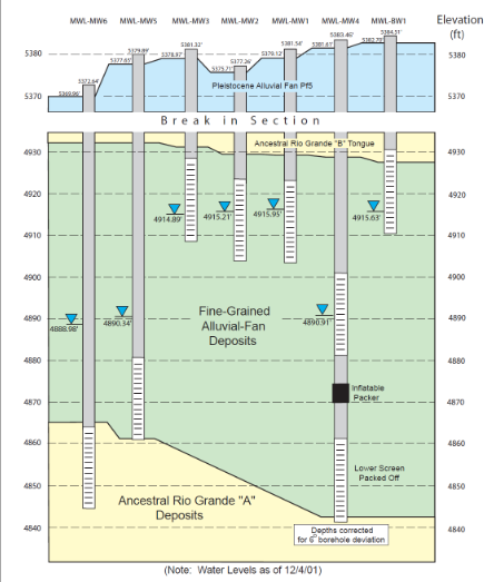
Source: Figure 3-13 in Mixed Waste Landfill Groundwater Report, 1990 through 2001, Sandia National Laboratories, Albuquerque, New Mexico SAND 2002-4098 (Goering et al., 2002).
Figure 7. Location of the eleven monitoring wells installed at the Sandia MWL dump over the years 1988 to 2008. The first four monitoring wells (MWL-MW1, -MW2 –MW3 and -
BW1 were installed in 1988 – 1989. The four new monitoring wells MWL-MW7, -MW8, - MW9 and -BW2 were installed in 2008.
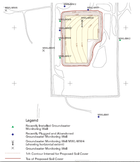
Scale 0….…….……...200 feet
Source: Figure 1-2 in Mixed Waste Landfill Groundwater Monitoring Report Calendar Year 2008, Sandia National Laboratories, May 27, 2009
Figure 8. The regional water level contour map in the Sandia 2008 Mixed Waste Landfill Annual Groundwater Monitoring Report. The map incorrectly shows the direction of groundwater travel below the MWL dump is to the northwest. The MWL dump is at the center of the figure.
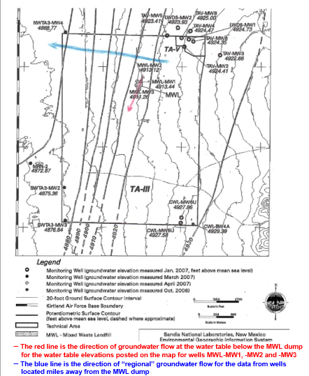
SOURCE: Figure 4.1-2 in Mixed Waste Landfill Annual Groundwater Monitoring Report, Spring 2007 Sampling Event Report Issued in February 2008.
Figure 9. Comparison of 1995 and 2008 Tritium sediment sample analytical results for the 10-, 30- and 50-foot depth samples at the Sandia MWL dump.
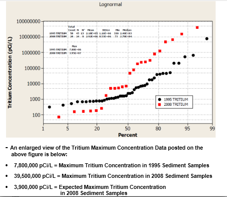
Note: The half-life of tritium is 12.3 years. Therefore, the maximum tritium concentration measured in the 2008 soil samples was expected to be 50% less than the maximum value measured 13 years earlier in 1995. The maximum value expected to be measured in the 2008 study was approximately 3,900,000 pCi/L.
However, the maximum tritium concentration measured in 2008 was 39,500,000 pCi/L and ten times greater than the expected maximum concentration. The high tritium concentrations measured in the 2008 samples is evidence of a new release of contamination from the wastes buried in the AWL dump. Source: Figure 6-6 in Investigation Report on the Soil-Vapor Volatile Organic Compounds, Tritium, and Radon Sampling at the Mixed Waste Landfill, August 2008 SNL/NM Environmental Restoration Project
Figure 10. The proposed locations for three vadose zone monitoring wells and the three existing soil-moisture monitoring tubes at the Sandia MWL dump.
Note: The three proposed vertical vadose zone monitoring wells are
MWL-VW1, MWL-VW2 and MWL-VW3. The three existing soil-moisture monitoring tubes installed at an angle below the MWL dump are MWL-VZ1, -VZ2 and -VZ3.
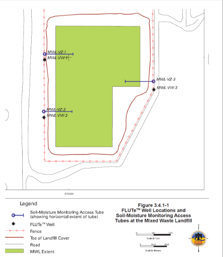
Source: Figure 3.4.1-1 in DOE/Sandia proposed Long-Term Monitoring and Maintenance Plan, September 2007